 That line circled in yellow highlighter indicates a public right of way still listed as current. It looks like any other road on the map. Any explorer of rural New England knows that the truth on the ground may look quite different.
Looking for an alternate route home after a tiring week, I examined a topographic map of the area around Stoddard Road, which had been my woodsy escape route through North Wolfeboro. Lately, cyclists had reported some bad dog incidents on Stoddard. Some dog owners have a way of relying on the public to train their unruly mutts for them. Cyclists often bear the brunt of this because we're not locked safely in an armored vehicle. I was in no mood to grind my way up Stoddard's considerable climbs only to have to deal with aggressive dogs as I wobbled over the crest.
I knew that Bickford Road goes to Haines Hill Road. It arrives there with a different name. The contours on the topographic map indicated that it comes into Haines Hill at the bottom of a tough climb that eventually leads to the same four-way intersection in North Wolfeboro that Stoddard Road enters. The contours also showed that the discontinued section of Bickford Road runs up a valley between the height of Stoddard Road and the rise of Haines Hill. It looked like a very agreeable gradient. Interesting that the two tougher roads have survived to the modern day while the easier one has fallen into disuse.
Typically I reach the Stoddard Road area by riding out the Cotton Valley Trail. Despite its many shortcomings, the Cotton Valley Trail follows a very convenient line. It is certainly free of motor vehicle traffic except if you encounter one of the rail cars for which the rails were left in place. These encounters are fairly rare.
Bickford Road began with a milder climb than the first one on Stoddard. That brought me to a beautiful little valley with a wetland in it, surrounded by the hills I would not be climbing.

 Sometimes when a road changes names you will find a sign indicating the change, even if there is no obvious intersection or direction change. I hoped such a sign might nail down for sure which set of ruts I should follow into the woods to come out where I expected to on Stoddard, where I'd passed the other end of the old road many times. I knew it would be pretty rough, but that's why I bought the Cross Check. Lately I'd stuck mostly to pavement, but that was more a matter of scheduling than a formal decision to give up absurd bushwhacks as a whole.
There was no sign when I reached the turn. It had to be the right one. The ruts were overgrown with encroaching growth and had obviously channeled some pretty healthy streams of water during the last big rainstorm. Immediately after I entered them I caught something under the thick grass and fell to the left. I yanked a foot out in time to prevent a full crash.
I was a few yards in when I decided to stop for a picture of the prospect.
 A little further on I snapped this shot of emergent rocks.
I pressed on without taking pictures of the two fallen trees that made me dismount and carry, or of some of the more thickly jungled sections in which saplings, tree branches, shrubbery and grasses stroked various insect life all over me.
For all of its obstacles it delivered on the promise of very gradual climbing. If the surface had been smooth I would have felt almost guilty about how completely I was cheating the hills.
Before I reached the junction with Stoddard Road I saw the back of a farm house I'd only ever seen from the front. By that I could tell that I had almost reached the maintained road.
 The ruts diverged as Bickford Road met Stoddard. The first shot shows the direction in which I continued.
 The second shot shows the direction from which I had always come. It also shows the contrast between a Class V maintained road and a Class VI right of way.
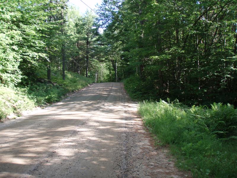
A Class VI right of way is still retained for public use, but nothing is done to ease passage through it. Some of them manage to keep looking a lot like a road because so many people use them. Others disappear into stands of trees and the imagination of cartographers.
I plucked a tick off my leg and crushed it between my fingernails before continuing on the familiar route home to a thorough shower.
Next time I try one of these routes I will wear more suitable shoes than my road cleats and bring some means of making fire so I can torch any ticks that get on me.
6 comments:
I love these bike accessable interstitial spaces. Conference Road in Santa Cruz County where I live is still marked as a road on some maps, but these days it's a rutted track that many people use as a shortcut. Here's video of me riding that road.
Nice, Fritz. I haven't managed to get my camera working so smoothly yet. I did notice that the wide angle lens really flattens things out, making the hills look unimpressive. I could tell by looking carefully that you have some nice rolling bits on that road.
If you have not done so have someone check you out completely for any more ticks. Lyme disease is not fun. It drained me for a few months last summer.
I definitely get checked after any wallow in the undergrowth. Teeny tiny ticks are fiendish adversaries and I have no medical coverage.
Ticks or no, that looks like a pretty nice detour now that you know your way through... I sometimes curse the relatively skinny slicks on my most days commuter...
[rexcuse]
Hey, Rantwick! I run 700X32 Panaracer T-Serv tires on my commuting rig. They provide sufficient flotation for the amount of soft stuff I usually encounter.They were a little skimpy for this bit, but because I never had to get up much of a climb I only felt them slip a couple of times. Knobs are such a liability when cornering hard on pavement that I don't dare use them. Everything is a compromise.
I may try this detour a few more times with more appropriate shoes. It's a tricky bit of steering as the smooth line shifts from left rut to raised center to right rut and back again.
Post a Comment